Topografische kaart 2 Botswana | Topographic Survey (0428896515581)
- ISBN / CODE: 0428896515581
- Schaal: 1:500000
- Uitgever: Topographic Survey
- Soort: Topografische kaart
- Taal: Engels
- Schrijf als eerste een review
-
€ 20,50
Uitverkocht, nooit meer leverbaar
.jpg)

.jpg)
-
Overzicht topografische kaarten Botswana

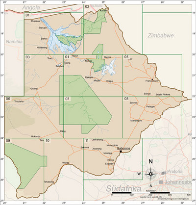
Producten op deze overzichtskaart:
Klik op een product om naar de pagina van dat product te gaan.
Overzichtskaarten
Beschrijving
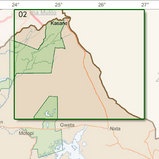
Kwalitatief goede topografische kaart van een deel Botswana. De serie bestaat uit 11 delen op schaal 1:500.000. Allemaal met UTM-grid.
Features of this map series:
This collection of charts covers Botswana in the scale of 1:500.000 and comprises a total of 11 individual sheets. The chart shown here is one of these sheets. The scale 1:500.000 means that 500.000 centimetres (5 kilometres) on the ground is represented by one centimetre on the chart, with good quality and accuracy.
The displayed details:
International boundaries; provincial boundaries; National Park boundaries; Railways; Power lines; Freeways; Arterial roads; Main roads; Secondary roads; Other roads; Hiking trails; Lighthouses; Mines; Plantaions and natural forests; Post offices; Police stations and stores; Schools; Churches and hotels; Telecommunication and FM towers; Perennial Water; Non-perennial waters; Dry pans; Pipelines, canals and waterpoints; Marshes, Vleis and sands; Urban areas and small centres
LET OP: Levertijd 2 - 3 weken
Reviews
Geen reviews gevonden voor dit product.
Schrijf een review
Graag horen wij wat u van dit artikel vindt. Vindt u het goed, leuk, mooi, slecht, lelijk, onbruikbaar of erg handig: schrijf gerust alles op! Het is niet alleen leuk om te doen maar u informeert andere klanten er ook nog mee!
Ook interessant voor afrika/botswana
-

Wegenatlas Traveller's Atlas Souther
€ 79,95Wegenatlassen Angola -

Reisgids Culture Smart! Botswana | K
€ 14,95Reisgidsen Botswana -

Natuurgids Stuart's Field Guide to M
€ 24,95Natuurgidsen Angola -

Vogelgids Birds of Botswana | Prince
€ 31,95Vogelgidsen Botswana -

Wegenkaart - landkaart Okavango Delt
€ 17,50Wegenkaarten Botswana