Categorieën
- Boeken
-
Kaarten
- Camperkaarten
- Educatieve kaarten
- Fietskaarten
- Fietsknooppuntenkaarten
- Historische Kaarten
- Pelgrimsroutes (kaarten)
- Spoorwegenkaarten
- Stadsplattegronden
- Toerskikaarten
- Topografische kaarten
- Wandelatlassen
- Wandelkaarten
- Wandelknooppuntenkaarten
- Waterkaarten
- Wegenatlassen
-
Wegenkaarten
- Afrika
- Azië
-
Europa
- Albanië
- Andorra
- Armenië
- Azerbeidzjan
- Belarus - Witrusland
- België
- Bosnië - Hercegovina
- Bulgarije
- Cyprus
- Denemarken
- Duitsland
- Engeland
- Estland
- Faroer
- Finland
- Frankrijk
- Georgië
-
Griekenland
- Vasteland Griekenland
- ■ Athene
- Macedonië (Griekenland)
- Epirus
- Thessalië
- Centraal-Griekenland
- Peloponnesos
- Griekse Eilanden
- Ionische Eilanden West
- ♦ Korfoe
- ♦ Kefalonia
- ♦ Lefkas
- ♦ Zakynthos
- Cycladen Zuid
- ♦ Santorini
- ♦ Mykonos
- ♦ Naxos
- Kreta
- Egeische Eilanden Noord-oost
- ♦ Limnos
- ♦ Samos
- ♦ Lesbos
- ♦ Chios
- Sporaden (midden - oost)
- Dodecanesos (zuid -oost)
- ♦ Karpathos
- ♦ Kos
- ♦ Rhodos - Rodos
- Saronische Eilanden - Golf van Egina
- Groenland
- Hongarije
- IJsland
- Ierland
- Italië
- Kosovo
- Kroatië
- Letland
- Liechtenstein
- Litouwen
- Luxemburg
- Malta
- Moldavië
- Monaco
- Montenegro
- Nederland
- Noord-Ierland
- Noord-Macedonië
- Noorwegen
- Oekraïne
- Oostenrijk
- Polen
- Portugal
- Roemenië
- Rusland
- Scandinavië
- Schotland
- Servië
- Slovenië
- Slowakije
- Spanje
- Tsjechië
- Turkije
- Vaticaanstad
- Zweden
- Zwitserland
- Midden-Amerika
- Midden-Oosten
- Noord-Amerika
- Oceanië
- Wereld
- Zuid-Amerika
- Wintersportkaarten
- Opruiming
- Puzzels
- Travel Gadgets
- Wandkaarten
- Wereldbollen
Veilig online betalen
Betaal veilig via uw eigen bankomgeving
- U bent hier:
- Home
- Europa
- Griekenland
- Ionische Eilanden West
- Kaarten
- Wegenkaarten
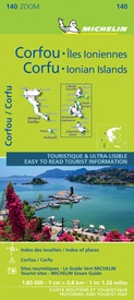
Wegenkaart - landkaart 140 Corfu & the Ionian Islands | Michelin (9782067248144)
- ISBN / CODE: 9782067248144
- Editie: 15-02-2021
- Aantal blz.: 1
- Schaal: 1:80000
- Uitgever: Michelin
- Soort: Wegenkaart
- Serie: Zoom
- Taal: Engels, Frans
- Hoogte: 25.0 cm
- Breedte: 11.0 cm
- Gewicht: 86.0 g
- Bindwijze: -
- Uitvoering: Papier
- Schrijf als eerste een review
-
€ 10,95
Op voorraad. Binnen 2 - 3 werkdagen in huis in Belgie Levertijd Nederland Voor 17.00 uur op werkdagen besteld, binnen 1 tot 2 werkdagen in huis in Nederland Levertijd Belgie
Gratis verzending in Nederland vanaf €35,-
- Afbeeldingen
- Inkijkexemplaar
Beschrijving
MICHELIN Zoom Map Corfu will give you an overall picture of your journey thanks to its clear and accurate mapping scale 1/80,000. Our map will help you easily plan your safe and enjoyable journey thanks to a comprehensive key, a complete name index as well a clever time & distance chart. Michelin's driving information will help you navigate safely in all circumstances. With MICHELIN National Maps, find more than just your way! Corfu, the northernmost of the Ionian Islands in Greece. Located off of the far northwest coast of the Greece, Corfu is in the Ionian sea, east of Italy and southwest of Albania. MICHELIN NATIONAL MAPS feature: * Up-to-date mapping * A scale adapted to the size of the country * A clear and comprehensive key * Distance and time chart * Place name index * Driving and road safety information * Tourist sights information Our maps are regularly updated even if the ISBN does not change.
Corfou, Iles grecques, Iles Ioniennes, Ithaque
Reviews
Geen reviews gevonden voor dit product.
Schrijf een review
Graag horen wij wat u van dit artikel vindt. Vindt u het goed, leuk, mooi, slecht, lelijk, onbruikbaar of erg handig: schrijf gerust alles op! Het is niet alleen leuk om te doen maar u informeert andere klanten er ook nog mee!
Ook interessant voor europa/griekenland/eilandenionischewest
-

Wandelkaart 301 Corfu - Korfoe | Roa
€ 9,95Wandelkaarten ♦ Korfoe -

Wegenkaart - landkaart Korfu - Corfu
€ 11,50Wegenkaarten ♦ Korfoe -

Wandelgids Corfu - Korfoe | Uitgever
€ 18,99Wandelgidsen ♦ Korfoe -

Reisgids Wat & Hoe Reisgids Korfoe |
€ 10,49Reisgidsen ♦ Korfoe -

Wandelgids Walking the Corfu Trail –
€ 17,50Wandelgidsen ♦ Korfoe


