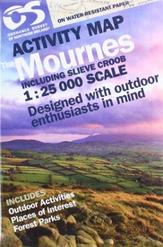
Wandelkaart The Mournes | Ordnance Survey Ireland (9781911643029)
- ISBN / CODE: 9781911643029
- Editie: 2019
- Schaal: 1:25000
- Uitgever: Ordnance Survey Ireland
- Soort: Wandelkaart
- Taal: Engels
- Hoogte: 35.5 cm
- Breedte: 21.8 cm
- Dikte: 0.9 cm
- Bindwijze: -
- Uitvoering: Scheur- en watervast
- Schrijf als eerste een review
-
€ 14,95
Op voorraad. Voor 17.00 uur op werkdagen besteld, morgen in huis in Nederland Levertijd Belgie
Gratis verzending in Nederland vanaf €35,-
Beschrijving
- Printed on water resistant paper
- Contours at 10 metre intervals
- Relief shading
- Historical and tourist information on the area
- Detailed geological map
- Map includes:
- Annalong Valley
- Castlewellan Forest Park
- Granite Trail
- Mourne Wall
- Mourne Way Rosstrevor to Newcastle
- Murlough National Nature Reserve
- Newcastle Way
- Silent Valley
- Slieve Donard
- Tollymore Forest Park
- Ulster Way Rosstrevor to Newcastle
- Author Publisher: Ordnance Survey of Northern Ireland
- Publication date: April 2019
- Format: Sheet map, folded
- Language: English
- Dimensions: 355 x 218 x 9 mm / 13.97 x 8.58 x 0.35 in
- Weight: 124 g / 4.37 oz
- Our Best Selling OS Northern Ireland Maps
Reviews
Geen reviews gevonden voor dit product.
Schrijf een review
Graag horen wij wat u van dit artikel vindt. Vindt u het goed, leuk, mooi, slecht, lelijk, onbruikbaar of erg handig: schrijf gerust alles op! Het is niet alleen leuk om te doen maar u informeert andere klanten er ook nog mee!


