Wandelkaart A12 tra Alghero e Sassari | Abies (0423043002075)
- ISBN / CODE: 0423043002075
- Schaal: 1:60000
- Uitgever: Abies
- Soort: Wandelkaart
- Taal: Engels
- Schrijf als eerste een review
-
€ 11,25
Uitverkocht, nooit meer leverbaar

Beschrijving
Many are the reasons why one should visit this area of Sardinia, not just for its wonderful beaches and its steep cliffs, its historical and cultural heritage or its natural sceneries, but also to discover and taste its gastronomic specialities that boast a great variety of typical dishes, based on genuine local products. The flavours of this cuisine - with recipes from the land and the sea - are tied to an ancient world but they have been also revised thanks to a great innovative skill. It is a cuisine that was born in the open air, with dishes that are inspired by the fields and the sheepfolds, or that are caught in the local clear waters, so rich of fish and crustaceans and specially of lobsters..
The coast of Sardinia on a series of contoured, GPS compatible maps at 1:60,000 from Ed. Abies with extensive tourist information including special recreational routes, plus additional coverage at more detailed scales of selected popular areas.
Main series at 1:60,000 (Nos. 1 to 12)
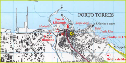
The maps have contours at 100m intervals and colouring for woodlands and maquis shrubland. Local trails are highlighted, with additional overprint for selected hiking, mountain bike and kayaking routes listed on the reverse of the maps with brief notes and grading for the degree of difficulty. All the maps have a UTM grid for GPS users.
Very extensive range of symbols highlight numerous places of interest and tourist facilities, including campsites and caravan parks, beaches, sport and recreational sites, archaeological remains and nuraghi, etc. The maps also indicate places where typical local products can be purchased. On the reverse each title has descriptions of its main places of interest, beaches, etc.
More detailed maps at 1:25,000/1:30,000 (Nos. 3A to 12A)
Contour interval is 25m, plus colouring for vegetation. Local trails are marked but unless indicated in the individual description, special routes are not included. Tourist overprint is also less extensive than on the 1:60,000 maps. Most titles have GPS coordinates. On the reverse are extensive notes describing the area. For more details see individual descriptions.
Map legend and additional text on all the maps includes English.
Reviews
Geen reviews gevonden voor dit product.
Schrijf een review
Graag horen wij wat u van dit artikel vindt. Vindt u het goed, leuk, mooi, slecht, lelijk, onbruikbaar of erg handig: schrijf gerust alles op! Het is niet alleen leuk om te doen maar u informeert andere klanten er ook nog mee!
Ook interessant voor europa/italie/sardinie
-

Wegenkaart - landkaart 3309 Sardinia
€ 17,50Wegenkaarten Sardinië -

Wandelkaart 7 Carta-guida Arcipelago
€ 15,95Wandelkaarten Sardinië -

Campergids Wohnmobil-Tourguide Sardi
€ 24,95Campergidsen Sardinië -

Reisgids Sardinia - Sardinië | Lonel
€ 20,95Reisgidsen Sardinië -

Wandelgids 5770 Wanderführer Sardini
€ 19,50Wandelgidsen Sardinië