Wandelkaart Garrotxa | Editorial Alpina (9788480903202)
Besalù, Olot, Santa Pau, Beuda, Sadernes

- ISBN / CODE: 9788480903202
- Schaal: 1:50000
- Uitgever: Editorial Alpina
- Soort: Wandelkaart
- Taal: Spaans
- Schrijf als eerste een review
-
€ 16,95
Uitverkocht, nooit meer leverbaar
.jpg)
Beschrijving
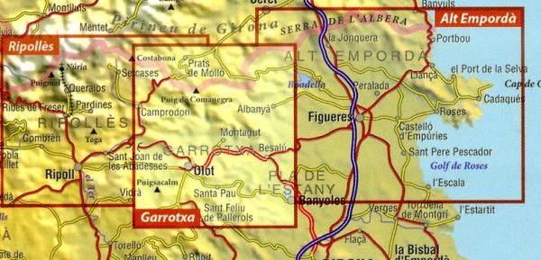
Zeer gedetailleerde wandelkaart van deel van de Spaanse Pyreneeen. Met ingetekende wandelroutes en andere informatie. Spaans en deel in het engels, maar uitstekende kaart. Met symbolen voor campings, hutten.
A topographic tourist map and hiking guide with details of tourist attractions, hiking & sporting activities as well as transport information. An excellent folded map & booklet. Hiking map and guidebook - Scale: 1:50.000 - Heights of the most interesting spots of the area - Shady relief - UTM grid with divisions of 1 km -Compatible with GPS - Marked routes - Guidebook with hikes, potholing, gully descent, climbing, mountain biking and facts of interest
The maps are contoured at 10 and 20 m intervals and feature hill shading and summit heights. All maps also feature long distance footpaths and hiking trails, campsites and camping huts. Each title has a separate booklet with general information on the area, descriptions of selected hiking routes, a list of accommodation with addresses, etc. and is presented in a plastic wallet.
- Legend in English
- Scale 1/50,000
- Coverage: Upper Garrotxa region; Albanya
- ISBN 9788480903769
- GPS compatible
- size: 155cm x 80cm
Reviews
Geen reviews gevonden voor dit product.
Schrijf een review
Graag horen wij wat u van dit artikel vindt. Vindt u het goed, leuk, mooi, slecht, lelijk, onbruikbaar of erg handig: schrijf gerust alles op! Het is niet alleen leuk om te doen maar u informeert andere klanten er ook nog mee!
Ook interessant voor europa/spanje/spaanse-pyreneeen
-

Wegenkaart - landkaart - Fietskaart
€ 16,95Fietskaarten Spaanse Pyreneeën -

Wandelgids 285 Pyrenäen 1 - Spanisch
€ 17,50Wandelgidsen Spaanse Pyreneeën -

Wandelkaart 21 Vall de Boi - Aiguest
€ 16,95Wandelkaarten Spaanse Pyreneeën -

Natuurgids - Reisgids Crossbill Guid
€ 29,95Natuurgidsen Spaanse Pyreneeën -

Wandelkaart 43 Taga - Serra Cavaller
€ 16,95Wandelkaarten Spaanse Pyreneeën