Mandje Tel: +31503126950 Menu
Winkelwagen
Geen items in winkelwagen
Ga naar winkelwagen

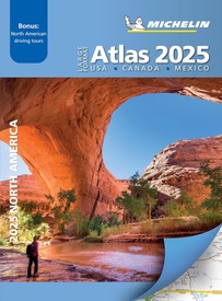
Wegenatlas Road Atlas 2025 USA - Canada - Mexico - Verenigde Staten groot formaat | Michelin (9782067263048)

plus enkele bladzijden Canada en Mexico

  • ISBN / CODE: 9782067263048
  • Editie: 2025
  • Aantal blz.: 128
  • Uitgever: Michelin
  • Soort: Wegenatlas
  • Taal: Engels
  • Hoogte: 38.7 cm
  • Breedte: 27.3 cm
  • Dikte: 0.9 cm
  • Uitvoering: -
  • Bindwijze: Paperback
  • Beoordeling: 4,9 ★★★★★ (14 reviews) Schrijf een review
  • 19,95

    Op voorraad. Binnen 2 - 3 werkdagen in huis in Belgie Levertijd Nederland Voor 17.00 uur op werkdagen besteld, morgen in huis in Nederland Levertijd Belgie

    Gratis verzending in Nederland vanaf €35,-

Beschrijving

De beroemde wegenatlas van Rand McNally nu als Michelin atlas op groot formaat, bijna dubbel A4. Elke staat een eigen, of soms zelfs twee pagina's. Uitgebreid register. Zoals de Amerikanen zelf zeggen: America's number 1 Road Atlas!

Canada en Mexico staan er zeer beperkt in.

Highlighting 51 road trips and scenic drives the Michelin's updated Large Format North America Road Atlas 2025 helps you enjoy the planning and the journey. Large-format maps and larger lettering for towns and sites (compared to the midsize atlas) make for easier reading while the tiled format flows maps from page to page—the ideal complement to GPS and online directions. Four jam-packed pages highlight selected US and Canadian national parks, with points of interest, hikes and drives.
 
Covers US, Canada & Mexico. Large grid map to quickly locate atlas pages.
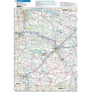
Easy-read text and mapping. Map pages are 36% larger than midsize atlas.
Inspired ideas for outdoor fun and road trip adventures in the US and Canada with four jam-packed pages highlighting selected national and provincial parks. Michelin's renowned travel guides are the resource for points of interest, hikes and scenic drives.
Tiled atlas format: user-friendly, convenient and logical to use, offering continuity when driving and providing the big picture to round out GPS and online directions.
Detailed place name index to quickly pinpoint destinations and sights.
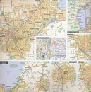
50+ large-scale city maps for navigating in and around cities.
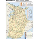
Distance chart for major US and Canadian cities, as well as convenient city-to-city mini distance chart on each two-page map spread, for more effective trip planning.
Tire tips to improve consumer driving safety.


Reviews

Prima wegenatlas

Als je buiten de Interstates ook via dorpjes wil rijden in de States is deze wegenatlas zeer aan te raden. Ook voor het uitzetten van een reis kan ik deze zeker aanbevelen.

★★★★★ door Maria Kessels 29 september 2019

Vond u dit een nuttige review? (login om te beoordelen)

-
Nee (0)
Prettig om mee te werken

Erg goed. Prettig om mee te werken.

★★★★★ door Frans haans 16 januari 2019

Vond u dit een nuttige review? (login om te beoordelen)

-
Nee (0)
Goede aankoop

Fijne, zeer goed bruikbare atlas. Goede aankoop.

★★★★★ door Toon van den Berg 22 maart 2018

Vond u dit een nuttige review? (login om te beoordelen)

-
Nee (0)
Toon meer reviews

Schrijf een review

Graag horen wij wat u van dit artikel vindt. Vindt u het goed, leuk, mooi, slecht, lelijk, onbruikbaar of erg handig: schrijf gerust alles op! Het is niet alleen leuk om te doen maar u informeert andere klanten er ook nog mee!