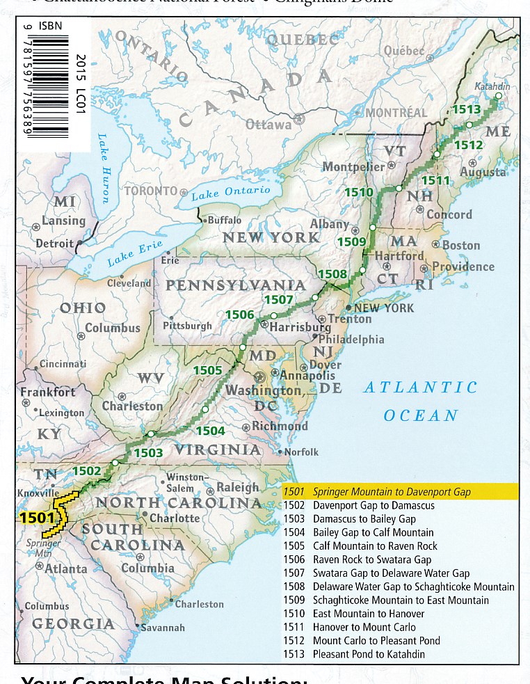
Wandelgids 1513 Topographic Map Guide Appalachian Trail – Pleasant Pond to Katahdin | National Geographic (9781597756501)
Maine

- ISBN / CODE: 9781597756501
- Editie: meest recente versie
- Schaal: 1:63360
- Uitgever: National Geographic
- Soort: Wandelgids
- Serie: Topographic Map Guide
- Taal: Engels
- Schrijf als eerste een review
-
€ 16,95
Leverbaar in 3 - 5 werkdagen in huis in Nederland Levertijd Belgie
Gratis verzending in Nederland vanaf €35,-


-
Appalachian Trail -National Geographic
Producten op deze overzichtskaart:
Klik op een product om naar de pagina van dat product te gaan.
- Wandelgids 1501 Topographic Map Guide Appalachian Trail - Springer Mountain to Davenport Gap | National Geographic
- Wandelgids 1502 Topographic Map Guide Appalachian Trail – Davenport Gap to Damascus | National Geographic
- Wandelgids 1503 Topographic Map Guide Appalachian Trail – Damascus to Bailey Gap | National Geographic
- Wandelgids 1504 Topographic Map Guide Appalachian Trail – Bailey Gap to Calf Mountain | National Geographic
- Wandelgids 1505 Topographic Map Guide Appalachian Trail – Calf Mountain to Raven Rock | National Geographic
- Wandelgids 1506 Topographic Map Guide Appalachian Trail – Raven Rock to Swatara Gap | National Geographic
- Wandelgids 1507 Topographic Map Guide Appalachian Trail – Swatara Gap to Delaware Water Gap | National Geographic
- Wandelgids 1508 Topographic Map Guide Appalachian Trail – Delaware Water Gap to Schaghticoke Mountain | National Geographic
- Wandelgids 1509 Topographic Map Guide Appalachian Trail – Schaghticoke Mountain to East Mountain | National Geographic
- Wandelgids 1510 Topographic Map Guide Appalachian Trail – East Mountain to Hanover | National Geographic
- Wandelgids 1511 Topographic Map Guide Appalachian Trail – Hanover to Mount Carlo | National Geographic
- Wandelgids 1512 Topographic Map Guide Appalachian Trail – Mount Carlo to Pleasant Pond | National Geographic
- Wandelgids 1513 Topographic Map Guide Appalachian Trail – Pleasant Pond to Katahdin | National Geographic
Overzichtskaarten
Beschrijving
Wandelgids/wandelatlas met weinig tekst, maar goede kaarten van een gedeelte van de Appalachian Trail.
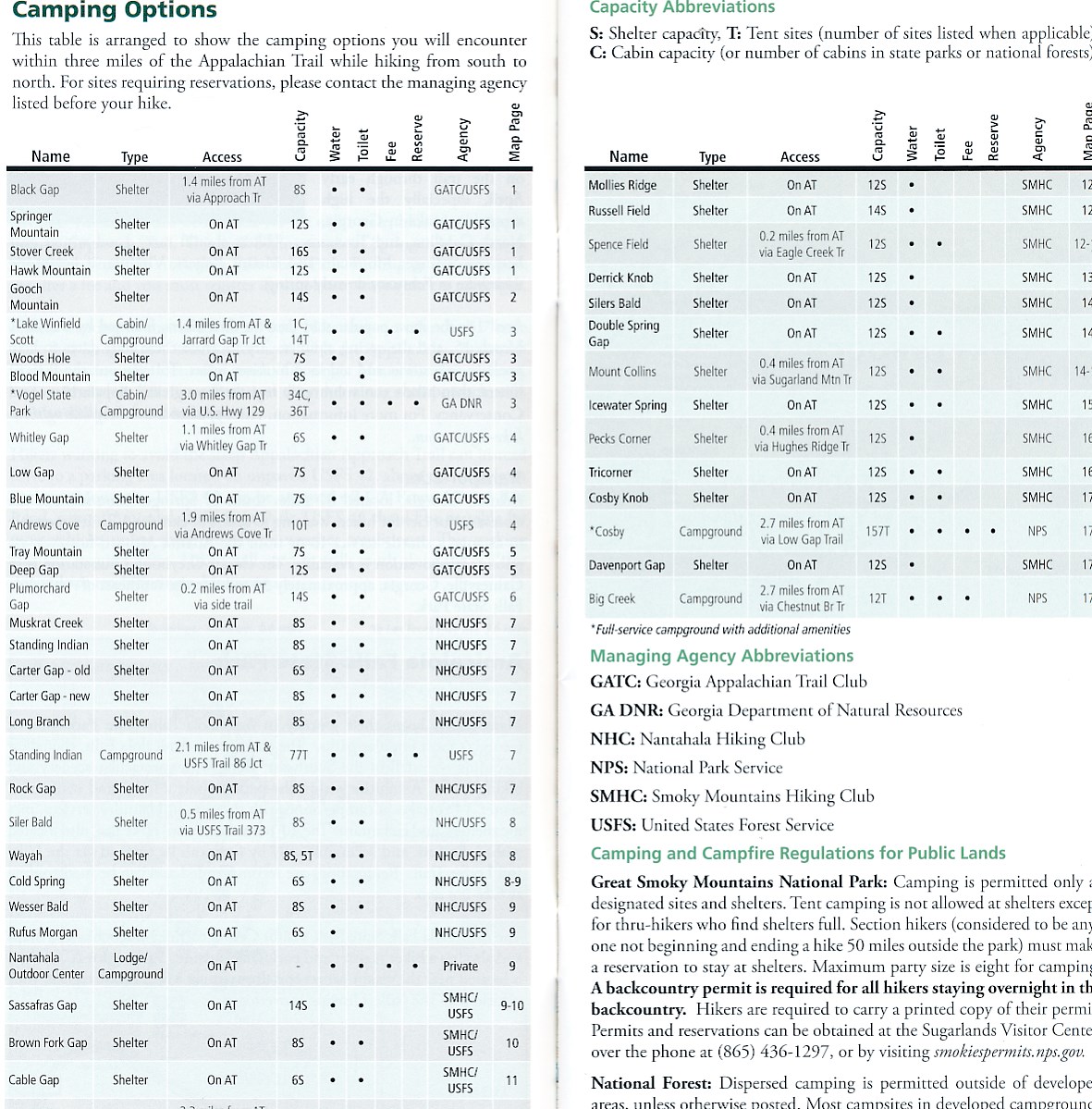
Each A.T. Topographic Map Guide includes detailed topographic maps at a detail of 1 inch = 1 mile. Each page is centered on the A.T. and overlaps with the adjacent pages so there is little chance of getting lost. Along the bottom of each page is a trail profile that shows the distance between shelters, camping areas, and trail access points. The map and trail profile provide a step by step visual guide to hiking the trail, mile by rugged mile. The Topographic Map Guide is built for all levels of hiking enthusiasts, from the day tripper to the multi month 'thru-hiker'. The front pages of the printed Topographic Map Guide include resupply information, town inset maps, camping options, and much more.
Reviews
Geen reviews gevonden voor dit product.
Schrijf een review
Graag horen wij wat u van dit artikel vindt. Vindt u het goed, leuk, mooi, slecht, lelijk, onbruikbaar of erg handig: schrijf gerust alles op! Het is niet alleen leuk om te doen maar u informeert andere klanten er ook nog mee!
Ook interessant voor noord-amerika/verenigde-staten-van-amerika/north-east
-

Wegenkaart - landkaart 583 Northeast
€ 11,95Wegenkaarten Canada Oost -

Wandelkaart - Topografische kaart 74
€ 17,95Topografische kaarten Nationale Parken Verenigde Staten van Amerika -

Reisgids Moon Best of Acadia Nationa
€ 22,50Reisgidsen Nationale Parken Verenigde Staten van Amerika -

Legpuzzel Niagara Falls - Niagara wa
€ 18,99Legpuzzels - 1000 stukjes Noordoost USA -

Natuurgids New York state wildlife |
€ 9,95Natuurgidsen Noordoost USA