National Geographic
Dit bekende tv-kanaal heeft naast prachtige natuurdocumontaires en magazines ook zijn eigen reisgidsen en wegenkaarten uitgegeven. De landkaarten zijn gedrukt op scheurvast en waterbestendig papier wat een vergrootte levensduur betekent. De kaarten zijn helder en bevatten een schat aan informatie voor zowel de 'gewone' toerist als de avonturier. De hoofdwegen zijn duidelijk aangegeven, maar ook de secundaire wegen en tracks staan er op. Met de nationale parken duidelijk en mooie zwemplekken of attracties aangegeven onderscheidt deze kaartenserie zich van de andere wegenkaarten. De kaarten heten dan ook niet voor niets Adventure Maps! Het avontuur wacht!
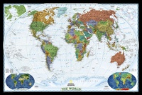 Wereldkaart World Decorator, 186 x 122 cm | National Geographic
This map has spectacular color and detail to bring the world alive! Enjoy the accuracy and beauty of this world map, which features the Winkel Tripel projection to reduce distortion …
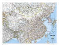 Wandkaart China, 76 x 59 cm | National Geographic
Decoratieve wandkaart van China. Naast de mooie kleuren staan er bijzonder veel plaatsen op vermeld. Het gaat soms een beetje ten kosten van de schoonheid van de kaart, maar daardoor …
★★★★★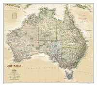 Wandkaart Australië, politiek & antiek, 77 x 60 cm | National Geographic
A current political map of Australia in rich, earth-toned colors clearly shows state boundaries, place names, bodies of water, parks and preserves, and more. Includes inset maps for Tasmania and …
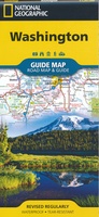 Wegenkaart - landkaart Guide Map Washington | National Geographic
The front side features insets of Olympia, Yakima and Spokane. The back includes a map and information for Seattle, information for Olympic, North Cascades, and Mt. Rainier National Parks, points …
★★★★★ Wandkaart USA Explorer, 81 x 51 cm | National Geographic
This colorful USA political map clearly shows state boundaries, capitals, major highways, rivers, lakes, and many major cities. Insets show detail of Alaska and Hawaii.
 Wereldkaart World Decorator, 108 x 75 cm | National Geographic
This map has spectacular color and detail to bring the world alive! Enjoy the accuracy and beauty of this world map, which features the Winkel Tripel projection to reduce distortion …
 Wereldkaart Politiek & antiek, pacific centered, 185 x 122 cm | National Geographic
The Pacific-centered map employs a new map projection to accentuate the Pacific Rim, and shows Oceania and Asia in close proportion to their actual size on the Earth. It brings …
 Wandkaart USA - Verenigde Staten Political, 178 x 124 cm | National Geographic
Het klassieke kaartbeeld van National Geographic, de grenzen van de staten van Amerika zijn apart gekleurd. De wandkaart is heel gedetailleerd met veel plaatsen, wegen, rivieren en nationale parken, het …
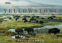 Fotoboek Yellowstone | National Geographic
Best-selling author David Quammen takes readers on a breathtaking journey through America's most inspiring and imperiled ecosystem--Yellowstone National Park--in this monumental book on America's first national park. Yellowstone's storied past, …
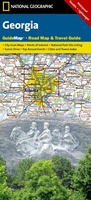 Wegenkaart - landkaart Guide Map Georgia | National Geographic
Makkelijk leesbare kaart aan 2 zijden bedrukt. De ene kan met informatie en beperkte stadsplattegronden, de andere met de daadwerkelijke kaart. De kaart is geplastificeerd en dus watervast! The front …
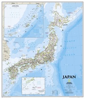 Wandkaart Japan, 63 x 74 cm | National Geographic
This classic-style map of Japan shows political boundaries, major highways and roads, cities and towns, airports, and other geographic details. Thousands of place-names and exact borders are carefully researched by …
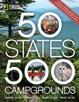 Campinggids - Campergids 50 States - 500 Campgrounds USA en Canada | National Geographic
Plan your next getaway to the great outdoors with this one-of-a-kind resource for campgrounds across North America. In this comprehensive sequel to the best-selling 50 States, 5,000 Ideas, you'll discover …
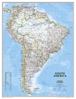 Wandkaart Zuid Amerika, politiek, 91 x 117 cm | National Geographic
Staatkundige kaart van Zuid-Amerika (in kleur). De kaart wordt verzonden in een koker. This classic map of South America shows political boundaries, place names, airports, major roads and highways, and …
 Wandkaart Afrika, politiek, 61 x 78 cm | National Geographic
Mooie wandkaart van Afrika, staatkundig, met rustig kleurgebruik en helder kaartbeeld, Ondanks het wat kleiner formaat staan er toch heel wat topografische details op vermeld. Kaart is up-to-date, alleen …
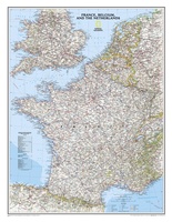 Wandkaart Frankrijk, België en Nederland, 60 x 77 cm | National Geographic
Our classic wall map of France, Belgium, and the Netherlands shows political boundaries, major highways and roads, cities and towns, and a wealth of other incredibly accurate geographic detail. n …
★★★★★ Wandkaart - Wandkaart Russia – Rusland, 77 x 60 cm | National Geographic
Decoratieve wandkaart van het land. Naast de mooie kleuren staan er bijzonder veel plaatsen op vermeld. National Geographic's classic wall map of Russia and the independent states of the former …
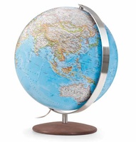 Wereldbol - Globe Fusion Classic Ø 37 cm | National Geographic
Fusion 3703 Classic, grote verlichte wereldbol met modern ontwerp van National Geographic Cartography (politiek, zeeën in blauw). Traditionele handlaminering, meridiaan en voet van geborsteld roestvrij staal. Inclusief spaarlamp, transparante kabel …
 Wandkaart Australië, politiek, 77 x 60 cm | National Geographic
Highly accurate Australia political map clearly shows state boundaries, place names, bodies of water, parks and preserves, and more. Includes inset maps for Tasmania and major Australian cities. This version …
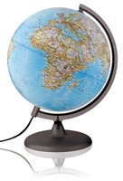 Wereldbol - Globe Classic Ø30 Nederlands met Verlichting | National Geographic
Deze verlichte wereldbol/globe van National Geographic (30 cm) met blauwe oceaan bevat meer dan 3800 plaatsnamen in het Nederlands. De tekst is duidelijk en elk land is afgebeeld in een …
★★★★★ Wandkaart Engeland en Wales, antiek, 76 x 91 cm | National Geographic
This earth-toned, executive-style map of England and Wales shows political boundaries, major highways and roads, cities and towns, airports, and other geographic details. Thousands of place-names and exact borders are …
Laatste reviews

Ondanks de moderne tijd met navigatie e.d. hebben we diverse reisboeken besteld. Dit is een prima keuze geweest. Het geeft veel meer rust om in …
★★★★★ door Con en Lizet Heijenrath 01 juni 2024 | Heeft dit artikel gekocht
Ondanks de moderne tijd met navigatie e.d. hebben we diverse reisboeken besteld. Dit is een prima keuze geweest. Het geeft veel meer rust om in …
★★★★★ door Con en Lizet Heijenrath 01 juni 2024 | Heeft dit artikel gekocht
Ik ben heel tevreden. Het waren de best beschikbare kaarten voor dat gebied. Met dank.
★★★★★ door Nico Kool 01 juni 2024 | Heeft dit artikel gekocht
Ik ben heel tevreden. Het waren de best beschikbare kaarten voor dat gebied. Met dank.
★★★★★ door Nico Kool 01 juni 2024 | Heeft dit artikel gekocht