Topografische kaart - Wandelkaart 0918SB La Trinité-Porhoët, Loudeac | IGN - Institut Géographique National (9782758535218)

- ISBN / CODE: 9782758535218
- Editie: meest recente versie
- Schaal: 1:25000
- Uitgever: IGN - Institut Géographique National
- Soort: Topografische kaart, Wandelkaart
- Taal: Frans
- Schrijf als eerste een review
-
€ 14,95
Leverbaar in 3 - 5 werkdagen in huis in Nederland Levertijd Belgie
Gratis verzending in Nederland vanaf €35,-


-
Topografische kaart IGN 25.000 Bretagne MIDDEN GEDEELTE

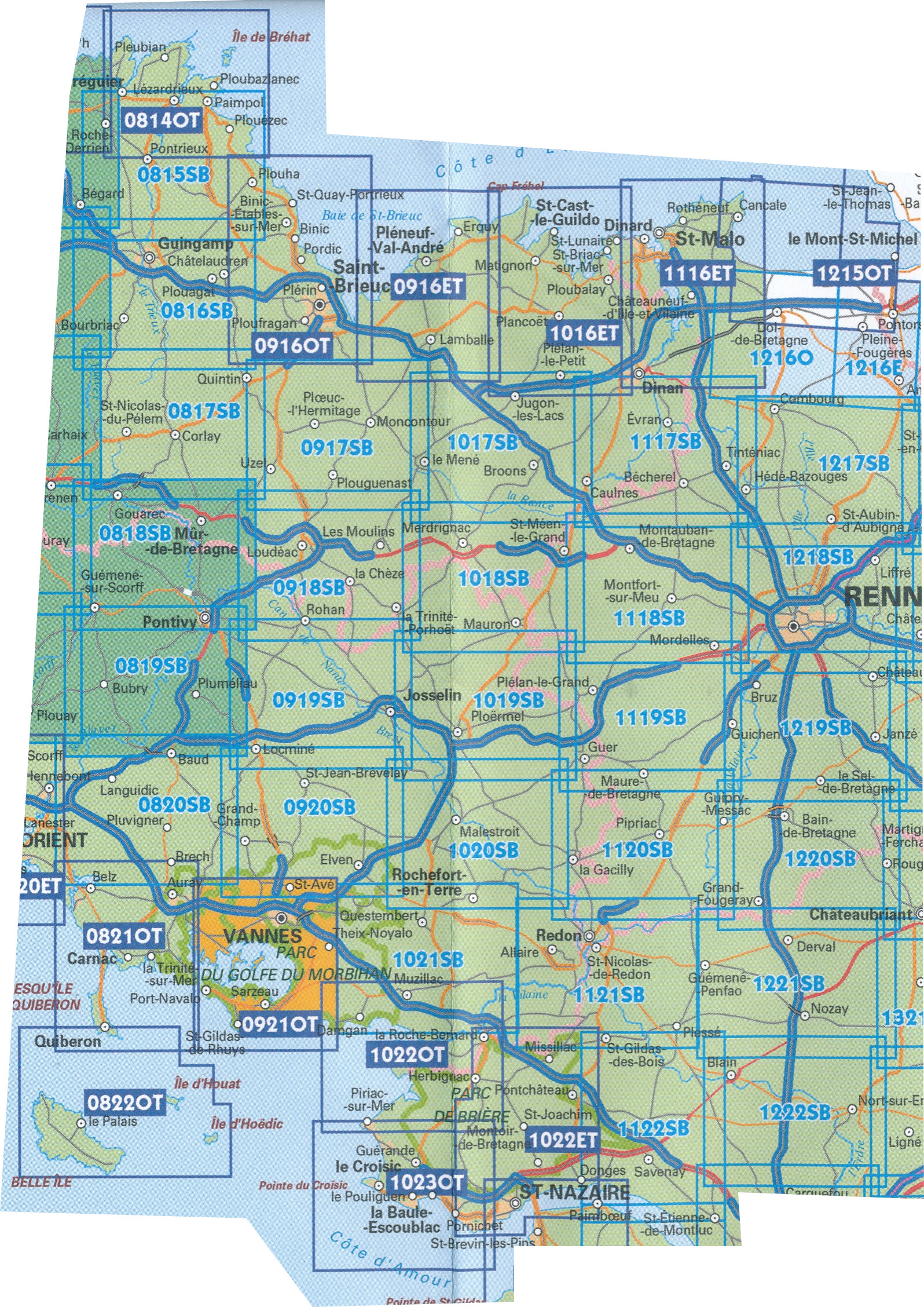
Producten op deze overzichtskaart:
Klik op een product om naar de pagina van dat product te gaan.
- Topografische kaart - Wandelkaart 0814OT Paimpol | IGN - Institut Géographique National
- Wandelkaart - Topografische kaart 0815SB Paimpol - Pontrieux | IGN - Institut Géographique National
- Wandelkaart - Topografische kaart 0816SB Guingamp | IGN - Institut Géographique National
- Wandelkaart - Topografische kaart 0817SB Quintin - St-Nicolas-du-Pelem | IGN - Institut Géographique National
- Wandelkaart - Topografische kaart 0818SB Pontivy | IGN - Institut Géographique National
- Wandelkaart - Topografische kaart 0819SB Pluméliau | IGN - Institut Géographique National
- Wandelkaart - Topografische kaart 0820SB Baud - Languidic | IGN - Institut Géographique National
- Wandelkaart - Topografische kaart 0821OT Presqu'Ile de Quiberon - Auray - Carnac Bretagne | IGN - Institut Géographique National
- Wandelkaart - Topografische kaart 0822OT Belle-Ile - Ile d'Houat et d'Hoëdic Bretagne | IGN - Institut Géographique National
- Wandelkaart - Topografische kaart 0916ET Erquy - le Val-André | IGN - Institut Géographique National
- Wandelkaart - Topografische kaart 0916OT Saint-Brieuc | IGN - Institut Géographique National
- Wandelkaart - Topografische kaart 0917SB Ploeuc-sur-Lié – Moncontour | IGN - Institut Géographique National
- Topografische kaart - Wandelkaart 0918SB La Trinité-Porhoët, Loudeac | IGN - Institut Géographique National
- Wandelkaart - Topografische kaart 0919SB Locmine - Josselin | IGN - Institut Géographique National
- Wandelkaart - Topografische kaart 0920SB Elven - Grand-Champ | IGN - Institut Géographique National
- Wandelkaart - Topografische kaart 0921OT Vannes | IGN - Institut Géographique National
- Wandelkaart - Topografische kaart 1016ET St.-Cast-le-Guildo - Cap Fréhel | IGN - Institut Géographique National
- Wandelkaart - Topografische kaart 1017SB Broons - Plenee Jugon | IGN - Institut Géographique National
- Wandelkaart - Topografische kaart 1018SB Saint-Méen-le-Grand – Merdrignac | IGN - Institut Géographique National
- Wandelkaart - Topografische kaart 1019SB Paimpont - Ploërmel | IGN - Institut Géographique National
- Wandelkaart - Topografische kaart 1020SB Malestroit - Peillac | IGN - Institut Géographique National
- Wandelkaart - Topografische kaart 1021SB Questembert - La Roche-Bernard | IGN - Institut Géographique National
- Wandelkaart - Topografische kaart 1022ET Saint-Nazaire & Parc Naturel Regional de Briere | IGN - Institut Géographique National
- Wandelkaart - Topografische kaart 1022OT La Roche-Bernard & Parc Naturel Regional de Briere | IGN - Institut Géographique National
- Topografische kaart - Wandelkaart 1023OT La Baule & Parc Naturel Regional de Briere | IGN - Institut Géographique National
- Wandelkaart - Topografische kaart 1116ET Saint-Malo – Dinard – Dinan – Rothéneuf – Cancale – Châteauneuf-d'ille-Vilaine | IGN - Institut Géographique National
- Wandelkaart - Topografische kaart 1117SB Dinan – Caulne -, Tinténiac | IGN - Institut Géographique National
- Wandelkaart - Topografische kaart 1118SB Montfort-sur-Meu – Montauban-de-Bretagne | IGN - Institut Géographique National
- Topografische kaart - Wandelkaart 1119SB Bréal-sous-Montfort, Guer | IGN - Institut Géographique National
- Wandelkaart - Topografische kaart 1120SB Pipriac – La Gacilly | IGN - Institut Géographique National
- Wandelkaart - Topografische kaart 1121SB Redon – St-Gildas-des-Bois | IGN - Institut Géographique National
- Topografische kaart - Wandelkaart 1122SB Savenay | IGN - Institut Géographique National
- Wandelkaart - Topografische kaart 1215OT Le Mont St.-Michel, Dol-de-Bretagne | IGN - Institut Géographique National
- Wandelkaart - Topografische kaart 1216SB Dol-de-Bretagne | IGN - Institut Géographique National
- Wandelkaart - Topografische kaart 1217SB Combourg – St-Aubin-d'Aubigné | IGN - Institut Géographique National
- Wandelkaart - Topografische kaart 1218SB Rennes – Cesson-Sévigné – Liffré | IGN - Institut Géographique National
- Wandelkaart - Topografische kaart 1219SB Bruz - Janzé | IGN - Institut Géographique National
- Wandelkaart - Topografische kaart 1220SB Bain-de-Bretagne – Rougé | IGN - Institut Géographique National
-
Wandelkaart IGN 25.000 Bretagne MIDDEN GEDEELTE

Producten op deze overzichtskaart:
Klik op een product om naar de pagina van dat product te gaan.
- Topografische kaart - Wandelkaart 0814OT Paimpol | IGN - Institut Géographique National
- Wandelkaart - Topografische kaart 0815SB Paimpol - Pontrieux | IGN - Institut Géographique National
- Wandelkaart - Topografische kaart 0816SB Guingamp | IGN - Institut Géographique National
- Wandelkaart - Topografische kaart 0817SB Quintin - St-Nicolas-du-Pelem | IGN - Institut Géographique National
- Wandelkaart - Topografische kaart 0818SB Pontivy | IGN - Institut Géographique National
- Wandelkaart - Topografische kaart 0819SB Pluméliau | IGN - Institut Géographique National
- Wandelkaart - Topografische kaart 0820SB Baud - Languidic | IGN - Institut Géographique National
- Wandelkaart - Topografische kaart 0821OT Presqu'Ile de Quiberon - Auray - Carnac Bretagne | IGN - Institut Géographique National
- Wandelkaart - Topografische kaart 0822OT Belle-Ile - Ile d'Houat et d'Hoëdic Bretagne | IGN - Institut Géographique National
- Wandelkaart - Topografische kaart 0916ET Erquy - le Val-André | IGN - Institut Géographique National
- Wandelkaart - Topografische kaart 0916OT Saint-Brieuc | IGN - Institut Géographique National
- Wandelkaart - Topografische kaart 0917SB Ploeuc-sur-Lié – Moncontour | IGN - Institut Géographique National
- Topografische kaart - Wandelkaart 0918SB La Trinité-Porhoët, Loudeac | IGN - Institut Géographique National
- Wandelkaart - Topografische kaart 0919SB Locmine - Josselin | IGN - Institut Géographique National
- Wandelkaart - Topografische kaart 0920SB Elven - Grand-Champ | IGN - Institut Géographique National
- Wandelkaart - Topografische kaart 0921OT Vannes | IGN - Institut Géographique National
- Wandelkaart - Topografische kaart 1016ET St.-Cast-le-Guildo - Cap Fréhel | IGN - Institut Géographique National
- Wandelkaart - Topografische kaart 1017SB Broons - Plenee Jugon | IGN - Institut Géographique National
- Wandelkaart - Topografische kaart 1018SB Saint-Méen-le-Grand – Merdrignac | IGN - Institut Géographique National
- Wandelkaart - Topografische kaart 1019SB Paimpont - Ploërmel | IGN - Institut Géographique National
- Wandelkaart - Topografische kaart 1020SB Malestroit - Peillac | IGN - Institut Géographique National
- Wandelkaart - Topografische kaart 1021SB Questembert - La Roche-Bernard | IGN - Institut Géographique National
- Wandelkaart - Topografische kaart 1022ET Saint-Nazaire & Parc Naturel Regional de Briere | IGN - Institut Géographique National
- Wandelkaart - Topografische kaart 1022OT La Roche-Bernard & Parc Naturel Regional de Briere | IGN - Institut Géographique National
- Topografische kaart - Wandelkaart 1023OT La Baule & Parc Naturel Regional de Briere | IGN - Institut Géographique National
- Wandelkaart - Topografische kaart 1116ET Saint-Malo – Dinard – Dinan – Rothéneuf – Cancale – Châteauneuf-d'ille-Vilaine | IGN - Institut Géographique National
- Wandelkaart - Topografische kaart 1117SB Dinan – Caulne -, Tinténiac | IGN - Institut Géographique National
- Wandelkaart - Topografische kaart 1118SB Montfort-sur-Meu – Montauban-de-Bretagne | IGN - Institut Géographique National
- Topografische kaart - Wandelkaart 1119SB Bréal-sous-Montfort, Guer | IGN - Institut Géographique National
- Wandelkaart - Topografische kaart 1120SB Pipriac – La Gacilly | IGN - Institut Géographique National
- Wandelkaart - Topografische kaart 1121SB Redon – St-Gildas-des-Bois | IGN - Institut Géographique National
- Topografische kaart - Wandelkaart 1122SB Savenay | IGN - Institut Géographique National
- Wandelkaart - Topografische kaart 1215OT Le Mont St.-Michel, Dol-de-Bretagne | IGN - Institut Géographique National
- Wandelkaart - Topografische kaart 1216SB Dol-de-Bretagne | IGN - Institut Géographique National
- Wandelkaart - Topografische kaart 1217SB Combourg – St-Aubin-d'Aubigné | IGN - Institut Géographique National
- Wandelkaart - Topografische kaart 1218SB Rennes – Cesson-Sévigné – Liffré | IGN - Institut Géographique National
- Wandelkaart - Topografische kaart 1219SB Bruz - Janzé | IGN - Institut Géographique National
- Wandelkaart - Topografische kaart 1220SB Bain-de-Bretagne – Rougé | IGN - Institut Géographique National
Overzichtskaarten
Beschrijving
In de loop van de periode 2014-2018 heeft IGN de 25.000 serie vervangen: de oude versies Est en Ouest (E en O aanduiding achter het nummer van de kaart) is verdwenen en vervangen door een kaart met nummer en gevolgd door de letters SB. In de meeste gevalen is het een samenvoeging van de E en O kaart, de SB kaart beslaat dan ook een groter gebied.
Reviews
Geen reviews gevonden voor dit product.
Schrijf een review
Graag horen wij wat u van dit artikel vindt. Vindt u het goed, leuk, mooi, slecht, lelijk, onbruikbaar of erg handig: schrijf gerust alles op! Het is niet alleen leuk om te doen maar u informeert andere klanten er ook nog mee!
Ook interessant voor europa/frankrijk/bretagne
-

Reisgids Capitool Reisgidsen Bretagn
€ 29,99Reisgidsen Bretagne -

Campergids 10 Mit dem Wohnmobil in d
€ 26,50Campergidsen Bretagne -

Wandelkaart - Topografische kaart 09
€ 16,95Topografische kaarten Bretagne -

Fietskaart - Wegenkaart - landkaart
€ 10,95Fietskaarten Bretagne -

Wandelgids 345 Cote d'Emeraude, GR34
€ 19,95Wandelgidsen Bretagne