Wandkaarten van landen - Schotland
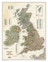 Wandkaart Groot Brittannië en Ierland antiek, 60 x 76 cm | National Geographic
This map of Britain and Ireland shows country boundaries, thousands of place names, major roadways, airports, bodies of water, and more. Rich earth-toned colors, astounding detail and boardroom quality make …
★★★★★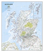 Wandkaart Schotland, 76 x 91 cm | National Geographic
This new map of Scotland, features our rich, antique-inspired Executive style. This beautiful map includes thousands of place names, accurate political boundaries, national parks, archeological sites, and major infrastructure networks …
★★★★★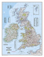 Wandkaart Britain and Ireland - Groot Brittannië en Ierland, 60 x 76 cm | National Geographic
This classic-style map of England and Wales shows political boundaries, major highways and roads, cities and towns, airports, and other geographic details. Thousands of place-names and exact borders are carefully …
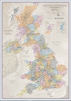 Wandkaart Classic Verenigd Koninkrijk | UK | Great Brittain | 85 x 60 cm | Maps International
Ontdek de rijke historie en schilderachtige landschappen van het Verenigd Koninkrijk met onze prachtige wandkaart, vormgegeven in een elegante klassieke stijl. Deze gedetailleerde kaart toont niet alleen de verschillende landen …
Laatste reviews

We hebben een landkaart van Albanië besteld. Deze hebben we in goede staat ontvangen
★★★★★ door Ida van der Heiden 26 april 2024 | Heeft dit artikel gekocht
Zoals gewend van de Alpverein weer een mooie en duidelijke kaart voor dit mooie wandelgebied incl. hutten.
★★★★★ door B van R 26 april 2024 | Heeft dit artikel gekocht
Duidelijke en mooie kaart van het gebied. Oogt stevig/dik waardoor niet snel kapot tijdens wandelingen. Sommige tekens zijn wel wat aan de kleine kant waardoor …
★★★★★ door B van R 26 april 2024 | Heeft dit artikel gekocht
Voor een reis Ivoorkust is er weiniginformatie te vinden. Dit boek brengt het meeste. Duidelijk en overzichtelijk.
★★★★★ door Annemiek van Riezen 26 april 2024 | Heeft dit artikel gekocht