National Geographic
Dit bekende tv-kanaal heeft naast prachtige natuurdocumontaires en magazines ook zijn eigen reisgidsen en wegenkaarten uitgegeven. De landkaarten zijn gedrukt op scheurvast en waterbestendig papier wat een vergrootte levensduur betekent. De kaarten zijn helder en bevatten een schat aan informatie voor zowel de 'gewone' toerist als de avonturier. De hoofdwegen zijn duidelijk aangegeven, maar ook de secundaire wegen en tracks staan er op. Met de nationale parken duidelijk en mooie zwemplekken of attracties aangegeven onderscheidt deze kaartenserie zich van de andere wegenkaarten. De kaarten heten dan ook niet voor niets Adventure Maps! Het avontuur wacht!
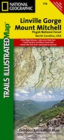 Wandelkaart - Topografische kaart 779 Linville Gorge - Mount Mitchell - Pisgah National Forest | National Geographic
Prachtige geplastificeerde kaart van het bekende nationaal park. Met alle recreatieve voorzieningen als campsites, maar ook met topografische details en wandelroutes ed. Door uitgekiend kleurgebruik zeer prettig in gebruik. Scheur …
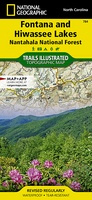 Wandelkaart 784 Fontana and Hiwassee Lakes | National Geographic
Prachtige geplastificeerde kaart van het bekende nationaal park. Met alle recreatieve voorzieningen als campsites, maar ook met topografische details en wandelroutes ed. Door uitgekiend kleurgebruik zeer prettig in gebruik. Scheur …
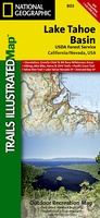 Wandelkaart - Topografische kaart 803 Lake Tahoe Basin | National Geographic
Prachtige geplastificeerde kaart van het bekende nationaal park. Met alle recreatieve voorzieningen als campsites, maar ook met topografische details en wandelroutes ed. Door uitgekiend kleurgebruik zeer prettig in gebruik. Scheur …
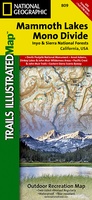 Wandelkaart - Topografische kaart 809 Mammoth Lakes - Mono Divide - Inyo and Sierra National Forests | National Geographic
Prachtige geplastificeerde kaart van het bekende nationaal park. Met alle recreatieve voorzieningen als campsites, maar ook met topografische details en wandelroutes ed. Door uitgekiend kleurgebruik zeer prettig in gebruik. Scheur …
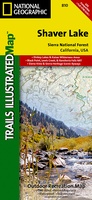 Wandelkaart - Topografische kaart 810 Shaver Lake - Sierra National Forest | National Geographic
Prachtige geplastificeerde kaart van het bekende nationaal park. Met alle recreatieve voorzieningen als campsites, maar ook met topografische details en wandelroutes ed. Door uitgekiend kleurgebruik zeer prettig in gebruik. Scheur …
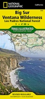 Wandelkaart 814 Topographic Map Guide Big Sur / Ventana Wilderness /CA | National Geographic
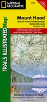 Wandelkaart - Topografische kaart 820 Mount Hood and Willamette National Forests | National Geographic
Prachtige geplastificeerde kaart van het bekende nationaal park. Met alle recreatieve voorzieningen als campsites, maar ook met topografische details en wandelroutes ed. Door uitgekiend kleurgebruik zeer prettig in gebruik. Scheur …
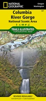 Wandelkaart - Topografische kaart 821 Columbia River Gorge National Scenic Area | National Geographic
Prachtige geplastificeerde kaart van het bekende nationaal park. Met alle recreatieve voorzieningen als campsites, maar ook met topografische details en wandelroutes ed. Door uitgekiend kleurgebruik zeer prettig in gebruik. Scheur …
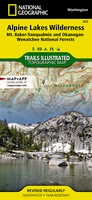 Wandelkaart 825 Alpine Lakes Wilderness /WA | National Geographic
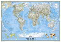
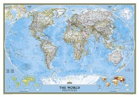
 Wereldkaart 82PH Politiek, 110 x 77 cm | National Geographic
Politieke wereldkaart van National Geographic. De klassieke blauwe vorm, met helder kaartbeeld. De landen hebben met kleuren duidelijke grenzen en er staan opvallend veel topografische details op. Ondanks de schaal …
 Magneetbord - Wereldkaart 82PM politiek, 110 x 77 cm | National Geographic
Politieke wereldkaart van National Geographic. De klassieke blauwe vorm, met helder kaartbeeld. De landen hebben met kleuren duidelijke grenzen en er staan opvallend veel topografische details op. Ondanks de schaal …
 Prikbord 82PM Wereldkaart, politiek, 110 x 77 cm | National Geographic
Politieke wereldkaart van National Geographic. De klassieke blauwe vorm, met helder kaartbeeld. De landen hebben met kleuren duidelijke grenzen en er staan opvallend veel topografische details op. Ondanks de schaal …
 Magneetbord 84M Wereldkaart, politiek, 176 x 122 cm | National Geographic
Politieke wereldkaart van National Geographic. De klassieke blauwe vorm, met helder kaartbeeld. De landen hebben met kleuren duidelijke grenzen en er staan opvallend veel topografische details op. Ondanks de schaal …
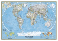
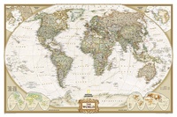
 Wereldkaart 84PH Politiek | 176 x 122 cm | National Geographic
Een bijzondere grote wereldkaart van National Geographic. Deze kaart is politiek van opbouw: alle landen worden met duidelijke grenzen heel goed zichtbaar. Daarnaast staan er veel plaatsen op en worden …
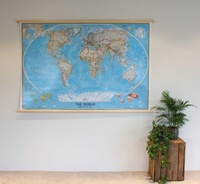
★★★★★ Prikbord 84PR Wereldkaart, politiek, 176 x 122 cm | National Geographic
Een bijzonder grote wereldkaart van National Geographic. Deze kaart is politiek van opbouw: alle landen worden met duidelijke grenzen heel goed zichtbaar. Daarnaast staan er veel plaatsen op en worden …
 Magneetbord - Wereldkaart 85PM Wereldkaart, World Political, 280 x 194 cm | National Geographic
Fantastische geplastificeerde wereldkaart van National Geographic. Deze kaart heeft een politiek kaartbeeld, waarbij met name de grenzen van landen in duidelijke kleuren zijn weergegeven. Hierdoor zijn de verschillende landen uitstekend …
 Wereldkaart 86 Politiek & antiek, 117 x 76 cm | National Geographic
Een prachtige, stijlvol gekleurde kaart - bruin, antieke kleurstelling - met een modern kaartbeeld. Alle landen staan er met grenzen en belangrijke steden keurig op, maar de nadruk ligt op …
★★★★★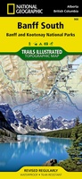 Wandelkaart 900 Banff South National Park | National Geographic
Prachtige geplastificeerde kaart van het bekende nationaal park. Met alle recreatieve voorzieningen als campsites, maar ook met topografische details en wandelroutes ed. Door uitgekiend kleurgebruik zeer prettig in gebruik. Scheur …
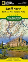 Wandelkaart 901 Banff North National Park | National Geographic
Prachtige geplastificeerde kaart van het bekende nationaal park. Met alle recreatieve voorzieningen als campsites, maar ook met topografische details en wandelroutes ed. Door uitgekiend kleurgebruik zeer prettig in gebruik. Scheur …
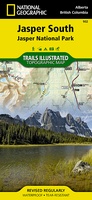 Wandelkaart - Wegenkaart - landkaart 902 Jasper South National Park | National Geographic
Goede kaart van een deel van Jasper National Park. Geschikt voor overzicht maar ook voor de langere trails: campsites, rivieren, paden, alles kun je er op terug vinden. National …
Laatste reviews

Heb de gids cadeau gedaan en die persoon was er heel blij mee ..
★★★★★ door J 21 november 2024 | Heeft dit artikel gekocht
De kaart van Kirgystan is prachtig, zeer gedetailleerd. Kan niet wachten tot de we echt op reis hmgaan die kant op.
★★★★★ door Marijke Eering 21 november 2024 | Heeft dit artikel gekocht
Super handig fiets boekje en mooi water bestendig. En handig om op de kaarten te kijken heel duidelijk beschrijving. Wij fietsen al jaren in Duitsland …
★★★★★ door Jenneke holterman 19 november 2024 | Heeft dit artikel gekocht
prima kaart levering en betaling allemaal vlot verlopen
★★★★★ door Marc Buts 19 november 2024 | Heeft dit artikel gekocht